Projects
A Project contains all of your plans, takeoff, and results relating to a site.
There are no limitations for the number of Projects you can save on your computer, but you can only open one at any given time.
TIP: It is important to regularly save your Project in MudShark so that you don't lose any data. We also recommend regularly backing up your Data Folder.
Understanding Project Metadata
You can save metadata for a Project, this is broken into three categories: Project, Client, and Ground Settings.
TIP: While no fields are mandatory, we do recommend entering a Project Name.
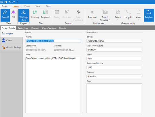
Project Details
All fields will start empty, however by default the Project will be named New Project [Creation Date] [Creation Time].
We advise changing the Name to better reflect the Project so you can identify it easier later. You can also add a Note for your Project.
You can enter a Site Address for a project, this is broken down into Street, Suburb, State, Postcode and Country. There is also a Note field for additional details about the Site Address.
Client Details
Client Details is broken down into three sections, Contact, Company and Company Address.
You can enter First name, Last name, Email, Mobile and Phone for a Contact.
TIP: You can only set one Contact per project, but you can use the Note field for additional contacts.
You can enter Name, Phone, and Fax for Company, and also enter the Company Address broken down into parts.
Ground Settings
Entering Ground Settings will have impact on the calculations for a Project.
By default, Strip by thickness will be 0, unless you have set a default in Options. You can change this value or select Strip Away and select any Layers you want to strip from your Proposed Site.
By default, Respread thickness is also set to 0, unless you have set a default in Options. This value is editable.
There are three other options available for you to check. By default Calculate Open Ground Fill is checked, which will calculate any fill without a structure on top.
You can check Only Use Proposed Contours For Structures and Spots, which will ignore contours and spots except for calculating structure surfaces if you’re using Overlay Options. By default, this is unchecked.
You can check Calculate Heat Map, this will generate a Heat Map for your Site that will show you the cut and fill depths. By default, this option is unchecked; checking it may increase the time it takes for your calculation to complete